Hit Enter to search or Esc key to close

History

History of Papua New Guinea

Main article: Archaeological evidence indicates that modern humans first arrived in what became New Guinea and Australia, as well as the Bismarck Archipelago, around 42,000 to 45,000 years ago. Bougainville was settled by around 28,000 years ago, and the more distant Manus Island by around 20,000 years ago. These were part of the earliest migrations of humans from Africa, and the resulting populations remained relatively isolated from the rest of the world throughout prehistory. Rising sea levels isolated New Guinea from Australia about 10,000 years ago, although Aboriginal Australians and New Guineans had already diverged from each other from about 37,000 years ago.

Geography

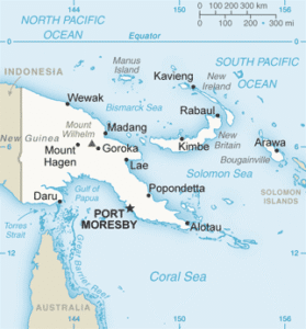
Papua New Guinea extends over 462,840 km2 (178,704 sq mi), including a large mainland and a number of islands. The country lies just south of the equator, and shares a land border with Indonesia, and maritime borders with Australia, the Solomon Islands, and the Federated States of Micronesia. The island of New Guinea lies at the east of the Malay Archipelago. The country is separated from Australia’s Cape York Peninsula by the shallow 152-kilometre (94 mi) Torres Strait. To the west of this strait is the shallow Arafura Sea, while to its east is the much deeper Coral Sea. The Gulf of Papua covers much of the southern coast, while the Solomon Sea lies east of the

Map

Papua New Guinea Tours

K1,035 Tour list image
K1,450 Tour list image
K1,359 Tour list image

Vietnam Hike, Bike & Kayak

Historic, Nautical 5 1 review 10 days
K5,327 Tour list image

Paris to Bordeaux

Agritourism, City Tour 4.5 2 review(s) 15 days
Chat With Us